As someone who has flown to Catalina Airport more times than I can count, I learned everything there is to know about this strip. Today, I will share it all with you.
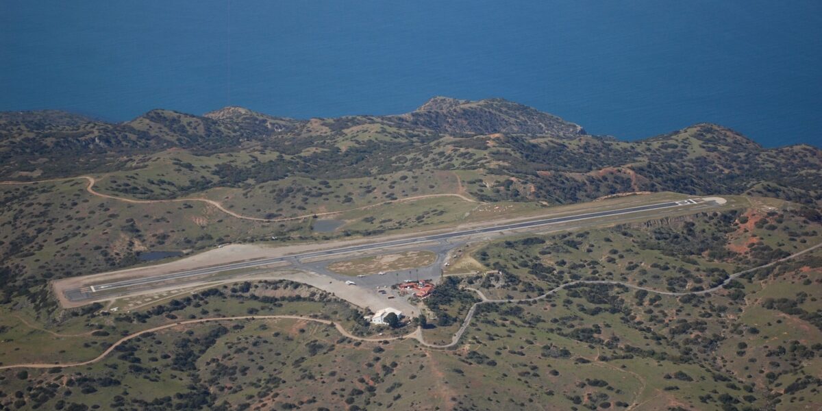
The approach, the views, the feeling of landing on an island 22 miles off the California coast — it never gets old. Catalina sits atop Santa Catalina Island, combining challenging flying with spectacular scenery and a genuine sense of arrival. The 3,250-foot runway at 1,602 feet elevation serves as the only airport on the island, and flying there has been a Southern California pilot pilgrimage for as long as there have been pilots in Southern California.
Quick Answer: Catalina Airport (KAVX) features a 3,250-foot runway at 1,602 feet elevation with a 1.7% upslope to the west. Operations use Runway 22 for arrival and Runway 04 for departure due to terrain and noise abatement. The island location requires overwater navigation. Landing fee is $35 for singles, $70 for twins. DC-3 Grill restaurant operates on-field. Accessible year-round but marine layer often closes the airport mornings May through July.
Airport Layout and Runway Details
The single runway (04/22) measures 3,250 feet long and 100 feet wide. Paved asphalt in good condition. Field elevation is 1,602 feet. Probably should have led with this, honestly, but the 1.7% gradient upslope to the west is what significantly aids both landings and departures — it’s the detail that matters most for planning. The airport sits on a plateau in the island’s interior with mountains rising over 2,000 feet to the northwest.
No lights exist, making this day VFR only. Fuel (100LL) is available with advance notice but not guaranteed — most pilots fuel on the mainland before departing. The small ramp accommodates 15-20 aircraft, which fills quickly on nice weekend mornings.
Standard Operating Procedures
Catalina uses published right-traffic patterns. The standard procedure is landing Runway 22 and departing Runway 04 regardless of actual wind conditions. This one-way operation prevents noise impacts over Avalon and provides better terrain clearance for departing aircraft. That’s what makes Catalina endearing to pilots who take the time to understand it: the procedures make complete sense once you know the terrain and community context.
Inbound aircraft contact Unicom (122.8) ten miles out. CTAF is 123.0. Overfly midfield at 2,000 feet to enter right downwind for Runway 22. The pattern keeps aircraft away from rising terrain to the north.
Overwater Navigation
The 22-mile crossing requires genuine preparation. Fly at 3,500 feet or higher to maintain gliding distance to shore if the engine quits. Wear life preservers. Carry a raft for night or IFR operations. Brief your passengers on ditching procedures before departure. These aren’t formalities — they’re safety measures for real risks over open water where help is not close.
Typical routes depart from Long Beach, Torrance, John Wayne, or other coastal airports. GPS makes navigation straightforward, but carry paper charts as backup. Monitor 121.5 and check weather at both ends since conditions differ significantly between mainland and island locations.
Weather Considerations
Marine layer fog blankets the island frequently from May through July. It typically burns off by noon but can persist longer. No weather reporting exists at Catalina, so pilots must assess conditions visually or obtain pilot reports from others who have flown recently. Mainland weather does not reliably predict island conditions. Always plan with enough fuel to return, because you may need to.
Landing Technique
Approach Runway 22 from the east. The upslope runway aids deceleration significantly, shortening landing roll to 1,000-1,500 feet for most aircraft. Maintain approach speed to avoid sinking short of the threshold. The 100-foot width feels narrower than mainland airports. The displaced threshold protects departing aircraft, so land beyond it.
Departure Procedures
Departures use Runway 04, taking advantage of the downhill slope. Backtaxi to the Runway 22 end for maximum available runway. The downhill slope provides excellent acceleration — most aircraft are airborne in 1,000-1,500 feet. After liftoff, turn right to parallel the island’s spine, keeping clear of Avalon.
On-Island Activities
The DC-3 Grill restaurant operates at the airport, serving meals inside a vintage DC-3 fuselage. It’s the main reason many pilots make the trip. Shuttle buses transport visitors to Avalon ($35 round trip) or Two Harbors. Most pilots spend two to four hours exploring before returning to the mainland. Overnight camping is possible with advance permits from the Catalina Island Conservancy.
Fees and Regulations
Landing fees are $35 for singles, $70 for twins. Pay at the airport office before you leave. Noise abatement compliance is critical — the airport faces periodic closure threats from community pressure, and every pilot’s behavior affects everyone else’s future access. Follow all published procedures. The island’s unique environment and genuinely challenging flying make Catalina a bucket-list destination for Southern California pilots. Treat it accordingly.


Leave a Reply