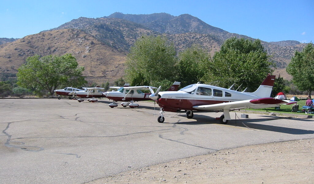
I’ve landed at Kern Valley Airport a dozen times over the years, usually on weekend flying trips to escape the LA basin. This little strip in the southern Sierra Nevada foothills serves the town of Kernville, California, and combines mountain scenery with reasonable access that makes it popular for weekend getaways and training flights. The 3,237-foot paved runway at 2,614 feet elevation handles most GA planes while getting you into some of the best outdoor recreation around Sequoia National Forest.
Quick reference: Kern Valley Airport (L05) has a 3,237-foot paved runway at 2,614 feet elevation in central California. Runway 15/33 has a slight gradient (1.8% uphill to the south). Facilities include self-serve 100LL, tie-downs, basic amenities. Town of Kernville is 1.5 miles away. Weather is VFR most days with occasional strong winds. No landing fees. Best for pilots with 150+ hp planes and mountain flying awareness.
The Runway Situation
Single runway (15/33) measures 3,237 feet long and 50 feet wide. Paved asphalt in good condition. Probably should have led with this, honestly: the elevation means you need to consider density altitude during summer. Runway has about a 1.8% gradient uphill to the south, which helps southbound landings and northbound departures but doesn’t dominate operations.
Both ends have clear approaches with reasonable obstacle clearance. Trees line the western boundary. Kern River flows along the eastern side. Mountains rise on all sides – typical Sierra foothill terrain. Pattern altitude is 3,600 feet MSL. CTAF is 122.9 for pilot-to-pilot advisories. No tower or weather reporting.
Fuel and Services
Self-serve 100LL is available 24 hours via credit card. Fuel prices typically run $1-$2 above metro airports due to the remote location. Check current prices before you show up to avoid surprises. Basic amenities include restrooms and a pilot lounge. No maintenance on-field – nearest A&P is in Bakersfield.
Landing Here
Standard patterns are left for Runway 15, right for 33. Wind typically flows along the valley, favoring northerly or southerly ops. Overfly at 500 feet above pattern altitude to check the sock and traffic. Monitor CTAF for other traffic.
Afternoon thermals and mechanical turbulence are common in summer. Morning flights offer calmer conditions. Terrain channels winds, sometimes creating challenging crosswinds. That’s what makes early departures standard practice among experienced mountain pilots.
Departures
Calculate density altitude before departure, especially summer afternoons. Temps over 90 degrees push DA to 5,000-6,000 feet. A 172 with 160 hp at gross needs about 2,000-2,500 feet at these DAs. The 3,237-foot runway provides decent margins for properly-loaded planes.
Morning departures offer way better performance. Use full runway length for all takeoffs. Abort capability drops past mid-field. Climb away from the airport before turning – ridges on both sides create terrain concerns. Follow the valley initially to gain altitude before crossing ridges.
What’s in Town
Kernville is a small town (population 1,400) catering to outdoor recreation. Kern River provides world-class whitewater rafting and kayaking. Fishing in the river and Lake Isabella (5 miles south) is excellent. Hiking trails access Sequoia National Forest. Several restaurants serve the tourist crowd. Town is 1.5 miles from the airport – walkable but long on hot days.
What to Fly
Most GA planes handle Kern Valley comfortably. Typical visitors include 172s and 182s, Piper Cherokees and Arrows, Mooneys, Bonanzas. Minimum recommended HP is 150, though 180 provides better margins in summer. Calculate weight and balance carefully. The DA, runway length, and terrain require performance margins. Avoid max gross in summer.
Safety Notes
While Kern Valley is more forgiving than high-altitude backcountry strips, it still demands mountain flying awareness. Don’t make Kern Valley your first mountain airport – build experience at easier locations first. Always have fuel reserves for diverting to Bakersfield if weather deteriorates. Valley can fill with smoke from wildfires during fire season. Kern Valley offers a great introduction to mountain flying with the safety margin of a paved runway and readily available fuel.
Leave a Reply