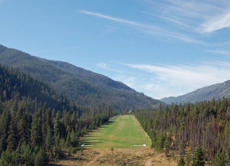
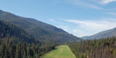
Smiley Creek Airport sits alongside Highway 75 in Idaho’s Sawtooth National Recreation Area, serving as a gateway to wilderness camping and mountain exploration. As someone who’s landed there multiple times, I can tell you it’s one of those strips that makes backcountry flying worthwhile. The 2,600-foot gravel runway handles a variety of aircraft while offering views of the Sawtooth Range that justify the flight alone.
Quick Answer: Smiley Creek (U87) features a 2,600-foot gravel runway at 7,200 feet elevation in central Idaho. The strip runs north-south with minimal obstacles and moderate gradient. No services available, so bring all supplies including fuel. Operations favor northbound landings and southbound departures when winds permit. Best season is June through September. Contact Sawtooth National Forest for current conditions: (208) 727-5000.
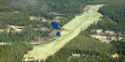
Airport Layout and Runway Details
The runway measures approximately 2,600 feet long and 60 feet wide. Surface is maintained gravel, sometimes smooth, sometimes showing the effects of recent weather. Elevation sits at 7,200 feet, which means density altitude calculations matter, especially on summer afternoons when you’re adding 2,000 feet or more to that number. Probably should have led with this, honestly, but the density altitude is the critical factor here.
Gradient is gentle by Idaho backcountry standards, roughly 2-3% upslope to the north. Trees border the east side while Highway 75 parallels the west boundary. Unlike many mountain strips, this one doesn’t force one-way operations. You have options, which is reassuring.
Approach and Landing Procedures
Standard operations favor landing to the north when winds cooperate. Overfly the strip at pattern altitude plus 500 feet to check conditions and traffic. Enter a left pattern, and expect a straightforward final with good visibility. Watch for vehicles on Highway 75, which runs close enough that the occasional tourist might wander onto the ramp.
The gravel surface provides decent braking, but speed control on final matters. Aim for the first third of the runway. Taxi slowly afterward unless you enjoy gravel damage to your propeller. That’s what makes Smiley Creek endearing to careful pilots: it rewards good technique without requiring heroics.
Departure Procedures
Departures typically use the full runway length. Southbound departure benefits from the downhill slope. Calculate takeoff performance based on actual density altitude, which on a July afternoon might exceed 9,000 feet. Most 180 hp aircraft need 1,500-2,000 feet under those conditions.
Morning departures provide significantly better performance. The temperature difference between 7 AM and 3 PM can mean 1,000-2,000 feet of density altitude variation. Plan accordingly.
Aircraft Suitability
Smiley Creek accommodates a range of aircraft. Cessna 172s, 182s, Super Cubs, Maules, and larger aircraft like Cessna 206s all visit regularly. Tailwheel is preferred but not required. Nosewheel aircraft operate successfully with proper technique. Minimum recommended horsepower is 150, though 180 provides better margins.
The relatively forgiving environment makes this an excellent “first backcountry strip” for pilots building experience. More accessible than Johnson Creek but still requiring respect for mountain flying principles. Remove wheel pants for gravel operations and bring tie-down stakes.
Facilities and Camping
No services exist at the airport. No fuel, no water, no restrooms. Bring everything you need. The nearest fuel is at Hailey (SUN), about 45 miles south. Smiley Creek Lodge operates just south of the airport, offering meals and basic supplies. The Salmon River headwaters provide water if you have filtration.
This is bear country. Store food properly and carry bear spray. Campfire restrictions apply during dry periods. Cell service ranges from limited to nonexistent. Satellite communication is recommended for genuine backcountry trips.
Seasonal Considerations
The strip operates June through September typically. Early season may have soft spots from snowmelt. July and August offer the most reliable conditions but highest density altitudes. September brings excellent weather with fall colors and cooler temperatures. Snow closes operations from October through May.
Summer afternoon thunderstorms develop regularly. Plan arrivals before early afternoon. Weather changes quickly in mountains, so monitor conditions continuously and maintain alternate plans. Stanley Airport (61U), 12 miles north, serves as a backup.
Area Activities
Smiley Creek provides access to Sawtooth National Recreation Area hiking trails. The Sawtooth Range rises dramatically to the west with numerous 10,000+ foot peaks. Fishing is excellent. Mountain biking trails wind through the area. The combination of accessibility and wilderness character attracts pilots seeking backcountry experience without extreme technical demands.
Safety Notes
Despite being more forgiving than many strips, Smiley Creek requires proper preparation. Calculate weight and balance carefully. Practice short-field procedures before attempting mountain strips. Fly with an experienced mountain pilot for your first visit if possible. File flight plans and carry appropriate survival gear. Treat every backcountry strip with respect.


Leave a Reply