Schafer Meadows gets you into Montana’s Bob Marshall Wilderness Complex – one of America’s biggest roadless areas. This remote Forest Service strip sits deep in wilderness only accessible by foot, horse, or aircraft. It’s genuine backcountry flying at its most serious. Not a beginner strip.
Quick Answer: Schafer Meadows (1S5) has a 2,600-foot grass runway at 4,750 feet elevation in northwestern Montana. Runs northeast-southwest with a moderate gradient and trees everywhere. Helena-Lewis and Clark National Forest operates it. No services – bring fuel, tools, everything. Open June through September. Call (406) 466-5341. Need mountain flying proficiency and tailwheel’s strongly recommended. One-way-in/one-way-out operations.
The Strip Layout
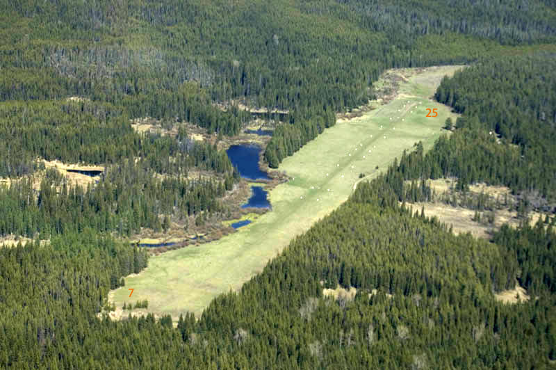
Grass runway’s about 2,600 feet long and 60 feet wide. Surface conditions vary big time – firmest in late summer, soft and muddy after spring snowmelt and rain. Elevation’s 4,750 feet. Runway runs northeast-southwest (designated 06/24) with about a 5-6% upslope to the northeast. That gradient’s significant – it dominates everything, requiring uphill landings and downhill departures.
Trees line both sides with higher terrain at both ends. Northeastern approach requires clearing trees with limited margin. Southwestern approach follows the meadow valley with better clearance. No lights, no markings, no services. Parking’s limited to grass areas near the runway. Forest Service maintains it minimally – this is legit backcountry flying requiring total self-sufficiency.
How Operations Work
Operations favor landing northeast (uphill) on Runway 06 and departing southwest (downhill) on 24 regardless of wind when possible. That gradient makes this one-way operation basically mandatory for safe ops. Overfly at 1,000 AGL to check surface conditions, look for wildlife (deer and elk hang out in the meadow), and check the sock.
No assigned CTAF – pilots use 122.9 for general advisories. Announce position and intentions though terrain blocks coverage. Standard pattern for Runway 06. Final approach requires clearing trees at the threshold – come in high and use that uphill gradient to kill energy. Aim for the first third. Most planes stop in 1,200-1,500 feet thanks to the upslope and grass.
Density Altitude’s a Killer
Summer afternoon density altitudes regularly hit 7,000-8,500 feet. Morning ops provide way better performance with 2,000+ foot DA differences compared to afternoon. A 182 with 180 hp at gross needs about 2,000-2,500 feet for takeoff at 8,000-foot DA. Downhill gradient cuts actual ground roll to 1,200-1,800 feet typically.
Calculate performance conservatively – use 1.5x book numbers as a safety margin. If you’re not flying by mid-runway on departure, abort immediately. Those trees at the departure end don’t forgive mistakes. Morning departures are mandatory during hot weather. Weight and balance are critical – many pilots reduce fuel or passengers to maintain margins. Never attempt max gross weight ops in summer.
Landing Technique
Northeastern approach follows the meadow with trees on both sides. Requires a steeper descent angle than typical patterns. Maintain airspeed discipline – high density altitude increases stall speeds. Don’t drag it in slow. Keep approach speed till you clear the trees, then chop power for the uphill landing. Gradient provides natural deceleration.
Grass surface’s often soft and uneven. Avoid heavy braking which may cause nosing over in taildraggers or stuck nosewheel in trikes. Let it roll uphill naturally. Soft-field technique applies – keep weight off the nosewheel, stick back pressure. Inspect the surface during taxi for holes, washouts, hazards. Taxi slow and careful to parking.
Departures
Departures require full runway length. Taxi to the northeastern turnaround. Do a careful runup checking mags and controls thoroughly – no maintenance help for hundreds of miles. Downhill slope provides substantial acceleration advantage. Short-field technique: full power against brakes, release, accelerate down the slope.
Liftoff happens 1,000-1,500 feet down the runway typically. Stay on runway heading till well clear of trees. Valley descends southwest providing good terrain clearance. Watch engine temps carefully – extended climbs at high power generate serious heat. Lean mixture for altitude, watch CHTs. Follow the drainage southwest till you’ve got altitude to cross ridges safely.
Camping and Activities
Schafer Meadows offers primitive camping near the runway. Forest Service maintains a guard station staffed seasonally. Vault toilets near camping area. Water from Schafer Creek – filter and treat it. No fuel, no power, no comms. It’s grizzly country – store food properly using bear canisters, hang bags, or approved storage. Carry bear spray always.
Several backcountry outfitters operate in the area offering guided hunting, fishing, pack trips. Maintained trail system accesses Bob Marshall Wilderness. South Fork Flathead River flows nearby with excellent fishing. The remoteness and wilderness character attract pilots seeking solitude and pristine backcountry. Most visitors spend 2-5 days exploring the wilderness.
Weather
Strip operates June through September usually. Early season brings soft field from snowmelt. July and August provide firmest surface but highest density altitudes. September offers excellent conditions with fall colors and cooler temps. Snow closes it October through May. Thunderstorms develop regularly in summer – get there before noon to dodge afternoon buildups.
Weather changes fast in the Northern Rockies. No weather reporting – you gotta assess visually. Nearest airport with weather’s Kalispell (50+ miles northwest). Weather there doesn’t predict Schafer conditions reliably. Always have alternate plans and fuel reserves to divert to Great Falls, Kalispell, or Missoula. Mountain wave turbulence happens in strong winds. Avoid ops when winds exceed 10-15 knots – terrain amplifies wind effects dramatically.
Safety and Experience
Schafer Meadows isn’t for inexperienced backcountry pilots. The gradient, surface conditions, high DA, and extreme remoteness create substantial hazards. You should have 50-100 hours backcountry experience before attempting Schafer. Take formal mountain flying training. Practice at easier strips like Big Creek or Cavanaugh Bay first. Tailwheel proficiency’s essential – nosewheel planes can operate here but at way higher risk.
Aircraft should have minimum 180 hp, preferably 200+. STOL mods help but aren’t substitutes for pilot skill. Bring comprehensive survival gear including shelter, fire starting, food, water purification, first aid, emergency comms. Satellite messenger or PLB’s mandatory – zero cell service. Emergency response takes days, not hours. Wilderness setting demands self-reliance and conservative decisions. Schafer Meadows rewards prepared, proficient pilots with an unforgettable Montana wilderness experience in one of America’s most remote and spectacular backcountry destinations.

Leave a Reply